The Nashville Basin
The Nashville Basin occupies the center of the Interior Plateau in Tennessee, as small part of northern Alabama and several counties in southern Kentucky. The Nashville Basin is bounded by the Eastern and Western Highland Rim. The entire region is unglaciated. The Nashville Basin is divided into the Inner Nashville Basin (or Inner Basin) and the Outer Nashville Basin (or Outer Basin). Woodland pastures, though less common than in the Bluegrass, are found throughout the region.
The Nashville Basin covers an area of 8,000 square miles (21,000 square km), of which more than three fourths is in the Outer Basin. The presence of the large city of Nashville, with a metropolitan population of 1.75 million, means that the Nashville Basin is more heavily urbanized and developed than the Bluegrass. Most of the development of the Nashville Basin is in the western portion of the Outer Basin, though there are several moderate size cities in the Inner Basin.
The Inner Basin is level to gently rolling. Soils are generally thin, with frequent outcrops of Ordovician limestone. The soils are redder and lower in phosphorus than those of either the Inner Bluegrass or the Outer Nashville Basin. , and the generally shallow soils are redder and lower in phosphorus. The karst terrain is dissected by gentle streams. The Inner Basin is very drought prone because of the excess drainage caused by the karst topography. All the typical trees of the woodland pasture habitat are present, but usually as individual trees or small groups of trees. The limestone cedar glades of Tennessee, a unique mixed grassland/forest cedar glades vegetation type with many endemic species, are located primarily on the limestones of the Inner Nashville Basin. The more xeric, open characteristics and shallow soils of the cedar glades also result in a distinct distribution of amphibian and reptile species. Urban, suburban, and industrial land use in the region is increasing.
The Outer Basin is more variable biologically and topographically than the Inner Basin with more rolling and hilly topography and slightly higher elevations. The region is largely composed of non-cherty Ordovician limestone bedrock similar to the Inner Basin, but it includes higher hills and knobs capped by the more cherty Mississippian age formations, and some Devonian-age Chattanooga shale, remnants of the Highland Rim. The region’s limestone rocks and soils are high in phosphorus, and commercial phosphate is mined. Deciduous forest and pasture the dominant non-urban land cover.
Geology. The Nashville Basin rests on a dome of Ordovician limestone, the same formation that creates the Bluegrass and part of the Cincinnati Arch. The Inner Basin has a number of shale beds interrupting the limestone, while the Outer Basin includes a number of steep hills capped by chert.
Limestone slowly dissolves as rain percolates through the rock. This creates a condition known as karst, in reference to the Karst Plateau of Slovenia and Northern Italy. Rain slowly dissolves the rock, creating cracks, fissures, sinkholes and caves. There are numerous small caves in the Inner Bluegrass and the Inner Nashville Basin.
Sinkholes are common throughout the Basin. The Inner Basin is also characterized by broad exposed beds of limestone with little soil, leading to the formation of cedar glades, which are open, impoverished areas surrounded by redcedar, blue ash and other trees.
In spite of our abundant rainfall, our streams often dry up quickly after rain, and pastures become very dry. Karst allows rain or melting snow to percolate quickly through the soil into the underlying rock. Instead of forest and crops, the Basin is dominated by grasslands and woodland pastures. Our trees are very drought tolerant and often rooted very deeply.
Land Use. The Nashville Basin is today a mosaic of land use, with extensive urbanization. Remaining land is divided between pastureland and forest. Most of the forest land is second growth that followed the abandonment of agricultural land in the early 20th century. Today, this forest land is mostly of poor quality and unproductive. Pastures vary in quality, from the thin-soiled marginal pastureland of the Inner Basin to the richer pastureland of the western Outer Basin. Urbanization has consumed the highest-quality pastureland to the south of Nashville.
In the Bluegrass, the high value of farmland, especially in the premier horse farm areas of the Inner Bluegrass, has provided some protection from growth and urbanization. The larger size of urban areas of the Nashville Basin and the lower overall value of farmland is leading to much more rapid conversion of farmland, including woodland pastures, to urban land.
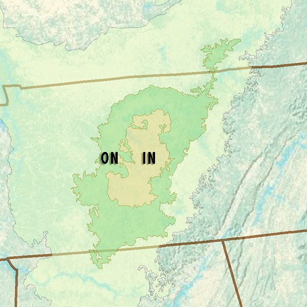
Ecoregions of the Nashville Basin. IN - Inner Basin, ON - Outer Basin
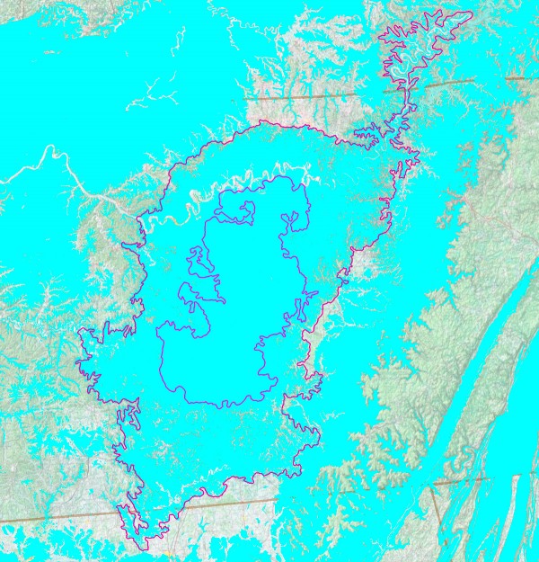
Limestone karst (blue) in the Nashville Basin.

Nashville Basin land use. Yellow=pasture, green=forest, brown=crops, red or pink=urban